
If you’ve ever watched the weather forecast and heard the term stationary front, you might have wondered what it actually means. Is it dangerous? Does it bring rain? Why does it matter? Most weather terms sound technical, but this one describes something surprisingly simple—and often quite familiar.
In this guide, we’ll break everything down using everyday language so you can understand what a stationary front is, why it forms, what kind of weather it brings, and how it affects our daily lives. Think of this as your friendly, no-jargon weather companion, here to help you make sense of a common but often overlooked weather pattern.
What Exactly Is a Stationary Front?
A simple definition anyone can understand
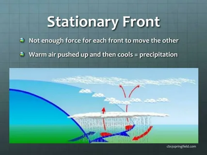
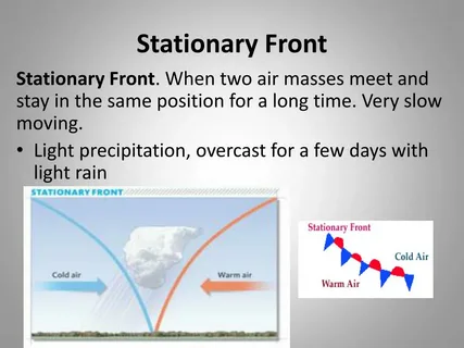
A stationary front occurs when a boundary between two air masses stops moving. It’s like a tug-of-war between warm air and cold air—but neither side is strong enough to pull the rope. The result is a sort of atmospheric standstill.
Why the name fits so perfectly
The word “stationary” tells the whole story: the front doesn’t move much. It can linger in the same area for hours, days, or sometimes even longer.
How Stationary Fronts Form
Two air masses meet but don’t mix
When warm, moist air encounters cooler, drier air, they form a boundary. Usually, one air mass pushes the other away, creating warm or cold fronts. But sometimes, the atmosphere doesn’t give either side enough force to advance.
A tug-of-war with no winner
Imagine two people leaning against each other with equal strength. They stay in place. A stationary front is the weather version of that balanced struggle.
The Weather You Can Expect During a Stationary Front
Clouds that seem to hang around
Stationary fronts often bring long stretches of cloudy skies. Because the air masses aren’t moving, clouds build and linger.
On-and-off rain or drizzles
Rainfall patterns can vary. Some areas may get light, steady drizzle, while others might experience scattered showers.
A good way to picture it: a wet sponge slowly dripping instead of someone tipping a bucket of water.
Humid conditions
The warm side usually pushes moisture upward, creating damp, sticky air if you’re in that region.
How Stationary Fronts Show Up on Weather Maps
Lines with alternating symbols
On most weather maps, stationary fronts appear as alternating blue triangles and red semicircles placed on opposite sides of the line.
What it means visually
The blue triangles point toward the warm air, and the red semicircles point toward the cold air. This design shows that neither side is advancing.
Stationary Front vs. Other Weather Fronts
How it differs from a cold front
A cold front actively pushes warm air upward. This often brings more dramatic weather—storms, sharp wind shifts, or temperature drops.
How it differs from a warm front
Warm fronts move slowly but steadily, bringing broader, lighter precipitation and gradual warming.
The stationary difference
When the front stops moving, the weather becomes persistent rather than dramatic.
Where Stationary Fronts Commonly Occur
Warm coastal areas
Regions near oceans or large lakes often see stationary fronts because water moderates temperatures, making air masses less aggressive.
Flat inland regions
Without mountains to force air upward or block movement, fronts can stall more easily.
Seasonal hotspots
Summer and early fall often bring more stationary fronts due to weaker wind patterns.
The Effects of Stationary Fronts on Daily Life
Long-lasting rain and grey skies
Because the front sticks around, so do the clouds. This can affect outdoor plans, agriculture, and even mood.
Temperature contrasts
On one side of the front, people may experience warmth and humidity, while just miles away, others feel cooler, drier air.
Travel considerations
Fog, wet roads, and low visibility can make driving or flying more challenging.
How Stationary Fronts Can Lead to Severe Weather
Thunderstorms along the boundary
If the warm side contains enough moisture and instability, storms may form repeatedly along the same zone.
Flooding risks
Repeated rainfall in the same area can lead to flash floods, especially in low-lying regions.
Eventual transformation
A stationary front can transform into a warm or cold front once one air mass becomes dominant, leading to sudden weather changes.
Practical Tips for Staying Safe During a Stationary Front
Check the forecast regularly
Because the weather can linger and change slowly, it’s good to keep an eye on updates.
Stay aware of rainfall totals
If your area has already seen a lot of rain, be alert for flooding.
Plan outdoor activities with flexibility
If skies look stubbornly grey, a stationary front might be the reason.
How Meteorologists Track Stationary Fronts
Satellite data
Meteorologists use satellite images to monitor cloud formation and movement.
Temperature gradients
A sharp difference in temperature across a boundary can signal an unmoving front.
Surface winds
Weak winds often indicate that the atmosphere lacks enough force to move the front forward.
The Life Cycle of a Stationary Front
Stage 1: Formation
Two air masses meet and stall.
Stage 2: Persistence
Clouds, moisture, and mild instability continue for hours or days.
Stage 3: Transformation
Eventually, one air mass weakens or a larger system arrives, turning the stationary boundary into a moving warm or cold front.
Stage 4: Dissipation
The temperature differences fade, and the front breaks apart.zWhy Stationary Fronts Matter for Climate and Weather Patterns
Moisture distribution
Stationary fronts can bring much-needed rainfall in dry regions—or too much rain in wet ones.
Influence on storm formation
They can serve as “breeding grounds” for low-pressure systems.
Impact on seasonal weather
Extended cloudy periods or persistent humidity can shape seasonal expectations.
Conclusion
A stationary front might sound like a complicated meteorological concept, but at its heart, it’s simply a boundary that refuses to budge. When warm and cold air compete without winning, the result is a stretch of cloudy skies, gentle rain, or occasionally, more intense weather. Understanding this pattern helps you interpret forecasts, plan your day, and appreciate the subtle dance of the atmosphere.
The next time you see alternating red and blue symbols on a weather map or notice days of steady drizzle, you’ll know exactly what’s happening—and why.
FAQs
1. How long can a stationary front last?
Some stationary fronts last a few hours, but others can linger for several days depending on wind patterns and atmospheric pressure.
2. Does a stationary front always bring rain?
Not always. It often leads to clouds and light precipitation, but sometimes it only brings humidity and mild temperature changes.
3. Can a stationary front turn into a storm system?
Yes. If enough moisture and instability build up, a stationary front can spark thunderstorms or develop into a more complex weather system.
4. Why do stationary fronts bring cloudy weather?
Warm, moist air rises slowly over cooler air along the boundary, creating layers of clouds that don’t move much because the front is stalled.
5. How can I identify a stationary front on a weather map?
Look for a line with alternating blue triangles and red semicircles pointing in opposite directions—this symbol shows the boundary is not advancing.